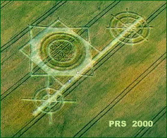
Photo by Peter Sorensen, Crop Circle Archives (Crop Circle Connector)
Blacklands, Wiltshire 30 July 2000, wheat, 24 photos
Date 30 July 2000
Place Blacklands, near Calne
County or region Wiltshire
Country England
Crop Wheat
GPS 51.40882, -1.97529
OS grid reference SU 0181 6775
Nearest ancient site Cherhill White Horse, 3.1 km Photos24
Photo by Peter Sorensen, Crop Circle Archives (Crop Circle Connector)
Photo by Stuart Dike, Crop Circle Archives (Crop Circle Connector)
Photo by Stuart Dike, Crop Circle Archives (Crop Circle Connector)
Photo by Stuart Dike, Crop Circle Archives (Crop Circle Connector)
Photo by Stuart Dike, Crop Circle Archives (Crop Circle Connector)
Photo by Stuart Dike, Crop Circle Archives (Crop Circle Connector)
Photo by Stuart Dike, Crop Circle Archives (Crop Circle Connector)
Photo by Stuart Dike, Crop Circle Archives (Crop Circle Connector)
Photo by Stuart Dike, Crop Circle Archives (Crop Circle Connector)
Photo by Stuart Dike, Crop Circle Archives (Crop Circle Connector)
Photo by Stuart Dike, Crop Circle Archives (Crop Circle Connector)
Photo by Stuart Dike, Crop Circle Archives (Crop Circle Connector)
Photo by Stuart Dike, Crop Circle Archives (Crop Circle Connector)
Photo by Stuart Dike, Crop Circle Archives (Crop Circle Connector)
Photo by Stuart Dike, Crop Circle Archives (Crop Circle Connector)
Photo by Janet Tucker, Crop Circle Archives (Crop Circle Connector)
Photo by Janet Tucker, Crop Circle Archives (Crop Circle Connector)
Photo by Janet Tucker, Crop Circle Archives (Crop Circle Connector)
Photo by Janet Tucker, Crop Circle Archives (Crop Circle Connector)
Photo by Andreas Muller, Crop Circle Archives (Crop Circle Connector)
Photo by Andreas Muller, Crop Circle Archives (Crop Circle Connector)
Photo by Andreas Muller, Crop Circle Archives (Crop Circle Connector)
Temporary Temples
Temporary Temples Photos load from the archives that published them and remain the copyright of their photographers. Crop circle images and reports courtesy The Crop Circle Connector (cropcircleconnector.com). All sources and credits .
Reports
Blacklands, nr Calne, Wiltshire. Reported 30th July. Blacklands, nr Calne, Wiltshire. Reported 30th July. GPS Reference SU01816775 Updated Wednesday 27th September 2000 Video image by Peter Sorensen. Copyright 2000 Click here to link to Peter's Homepage and see more of his crop circle pictures. Here's the odd…