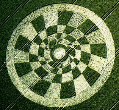
Photo by Nick Nicholson and the Crop Circle Connector, Crop Circle Archives (Crop Circle Connector)
- Date
- 24 June 2003
- Place
- Tan Hill, near Stanton St Bernard
- County or region
- Wiltshire
- Country
- England
- Crop
- Wheat
- GPS
- 51.36998, -1.85982
- OS grid reference
- SU 0985 6344
- Nearest ancient site
- Alton Barnes White Horse, 1.3 km
- Reference codes
- LP-CCDB uk2003ay
Photos10
Photos load from the archives that published them and remain the copyright of their photographers. Crop circle images and reports courtesy The Crop Circle Connector (cropcircleconnector.com). All sources and credits.
Reports
Crop Circle Archives (Crop Circle Connector)
Crop Circle at Tan Hill, nr Stanton St Bernard, Wiltshire. Reported 24th June 2003. Tan Hill, nr Stanton St Bernard, Wiltshire. Reported 24th June. Map Ref: SU09856344 Updated Monday 13th October 2003 Image Nick Nicholson and the Crop Circle Connector Copyright 2003 PLEASE NOTE The top picture was taken the day…
Photos by Nick Nicholson and the Crop Circle Connector, M.J.Fussell, Bertold Zugelder. Read the full report at Crop Circle Archives.
Lucy Pringle Crop Circle Photography
A complex series of concentric circles divided into multiple radial 'checker board' portions
Photos by Lucy Pringle. Read the full report at Lucy Pringle.