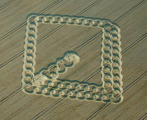
Photo by John Dove, Crop Circle Archives (Crop Circle Connector)
- Date
- 2 August 2003
- Place
- East Field, near Alton Barnes
- County or region
- Wiltshire
- Country
- England
- Crop
- Wheat
- GPS
- 51.36729, -1.83261
- OS grid reference
- SU 117 631
- Nearest ancient site
- Adam's Grave, 0.5 km
- Reference codes
- LP-CCDB uk2003cn
Photos11
Photos load from the archives that published them and remain the copyright of their photographers. Crop circle images and reports courtesy The Crop Circle Connector (cropcircleconnector.com). All sources and credits.
Reports
Crop Circle Archives (Crop Circle Connector)
Crop Circle at East Field, nr Alton Barnes, Wiltshire. reported 2nd August 2003. East Field, nr Alton Barnes, Wiltshire. Reported 2nd August. Map Ref: SU117631 Updated Tuesday 9th September 2003 Image John Dove Copyright 2003 Image Copyright www.temporarytemples.co.uk 2003 The Late Late show East Field , has become…
Photos by John Dove. Read the full report at Crop Circle Archives.
Crop Circle Archives (Crop Circle Connector)
Crop Circle at West Overton, nr East Kennett, Wiltshire. Reported 31st July 2003. West Overton, nr East Kennett, Wiltshire. Reported 31st July. Map Ref: Updated Friday 8th August 2003 Image Copyright www.temporarytemples.co.uk 2003 Image Andrew King Copyright 2003 Images Peter Sorensen Copyright 2003 Sorry, but…
Photos by Andrew King, Peter Sorensen. Read the full report at Crop Circle Archives.
Lucy Pringle Crop Circle Photography
A circle with a ring around it and a path sticking out from one side A circle with a ring around it and a path sticking out from one side - showing nearby woods
Photos by Lucy Pringle. Read the full report at Lucy Pringle.