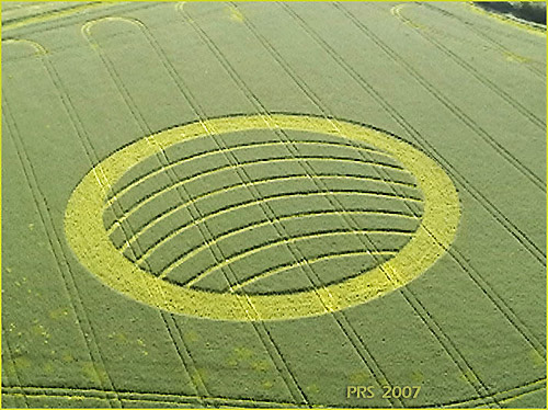
Photo by Sorensen, Crop Circle Archives (Crop Circle Connector)
Oliver's Castle, Wiltshire 15 April 2007, oilseed rape, 29 photos
Date 15 April 2007
Place Oliver's Castle, near Devizes
County or region Wiltshire
Country England
Crop Oilseed Rape
GPS 51.38270, -1.99779
OS grid reference SU 002 648
Nearest ancient site Cherhill White Horse, 6.3 km
Reference codes LP-CCDB uk2007aa Photos29
Photo by Sorensen, Crop Circle Archives (Crop Circle Connector)
Photo by John Dove, Crop Circle Archives (Crop Circle Connector)
Photo by Lucy Pringle, Crop Circle Archives (Crop Circle Connector)
Photo by Lucy Pringle, Crop Circle Archives (Crop Circle Connector)
Photo by John Dove, Crop Circle Archives (Crop Circle Connector)
Photo by Nicholson, Crop Circle Archives (Crop Circle Connector)
Photo by Nicholson, Crop Circle Archives (Crop Circle Connector)
Photo by Nicholson, Crop Circle Archives (Crop Circle Connector)
Photo by Nicholson, Crop Circle Archives (Crop Circle Connector)
Photo by Nicholson, Crop Circle Archives (Crop Circle Connector)
Photo by Nicholson, Crop Circle Archives (Crop Circle Connector)
Photo by Nicholson, Crop Circle Archives (Crop Circle Connector)
Photo by Nicholson, Crop Circle Archives (Crop Circle Connector)
Photo by Bertold Zugelder, Crop Circle Archives (Crop Circle Connector)
Photo by Charles Mallett, Crop Circle Archives (Crop Circle Connector)
Photo by Charles Mallett, Crop Circle Archives (Crop Circle Connector)
Photo by Charles Mallett, Crop Circle Archives (Crop Circle Connector)
Photo by Tommy Borms, Crop Circle Archives (Crop Circle Connector) , diagram
Photo by M. Scott, Crop Circle Archives (Crop Circle Connector)
Photo by Charles Mallett, Crop Circle Archives (Crop Circle Connector)
Photo by Charles Mallett, Crop Circle Archives (Crop Circle Connector)
Photo by Charles Mallett, Crop Circle Archives (Crop Circle Connector)
Photo by Charles Mallett, Crop Circle Archives (Crop Circle Connector)
Photo by Charles Mallett, Crop Circle Archives (Crop Circle Connector)
Photo by Charles Mallett, Crop Circle Archives (Crop Circle Connector)
Photo by John Dove, Crop Circle Archives (Crop Circle Connector)
Photo by Lucy Pringle, Lucy Pringle Crop Circle Photography
Photo by Lucy Pringle, Lucy Pringle Crop Circle Photography
Photo by Lucy Pringle, Lucy Pringle Crop Circle Photography Photos load from the archives that published them and remain the copyright of their photographers. Crop circle images and reports courtesy The Crop Circle Connector (cropcircleconnector.com). All sources and credits .
Reports
Crop Circle at Oliver's Castle, Nr Devizes, Wiltshire. Reported 15th April 2007. Oliver's Castle, Nr Devizes, Wiltshire. Reported 15th April. Map Ref: Map Ref: SU002648 This Page has been accessed Updated Thursday 24th May 2007 AERIAL SHOTS GROUND SHOTS DIAGRAMS FIELD REPORTS Image Peter Sorensen Copyright 2007…
A large ring with seven arcs spanning the centre A large ring with seven arcs spanning the centre