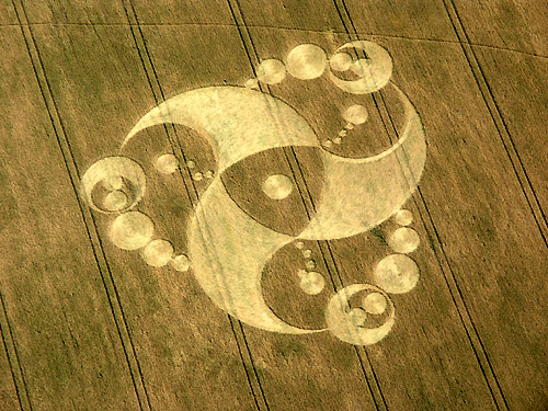
Photo by John Montgomery, Crop Circle Archives (Crop Circle Connector)
Martinsell Hill, Wiltshire 27 July 2008, wheat, 31 photos
Date 27 July 2008
Place Martinsell Hill, near Oare
County or region Wiltshire
Country England
Crop Wheat
Reference codes LP-CCDB uk2008bl Photos31
Photo by John Montgomery, Crop Circle Archives (Crop Circle Connector)
Photo by John Montgomery, Crop Circle Archives (Crop Circle Connector)
Photo by John Montgomery, Crop Circle Archives (Crop Circle Connector)
Photo by Frank Laumen, Crop Circle Archives (Crop Circle Connector)
Photo by Lucy Pringle, Crop Circle Archives (Crop Circle Connector)
Photo by Lucy Pringle, Crop Circle Archives (Crop Circle Connector)
Photo by Wccsg, Crop Circle Archives (Crop Circle Connector)
Photo by Wccsg, Crop Circle Archives (Crop Circle Connector)
Photo by Wccsg, Crop Circle Archives (Crop Circle Connector)
Photo by Bertold Zugelder, Crop Circle Archives (Crop Circle Connector)
Photo by Amy Young, Crop Circle Archives (Crop Circle Connector)
Photo by Amy Young, Crop Circle Archives (Crop Circle Connector)
Photo by Amy Young, Crop Circle Archives (Crop Circle Connector)
Photo by Amy Young, Crop Circle Archives (Crop Circle Connector)
Photo by Amy Young, Crop Circle Archives (Crop Circle Connector)
Photo by Amy Young, Crop Circle Archives (Crop Circle Connector)
Photo by Amy Young, Crop Circle Archives (Crop Circle Connector)
Photo by Amy Young, Crop Circle Archives (Crop Circle Connector)
Photo by Amy Young, Crop Circle Archives (Crop Circle Connector)
Photo by Amy Young, Crop Circle Archives (Crop Circle Connector)
Photo by Amy Young, Crop Circle Archives (Crop Circle Connector)
Photo by Amy Young, Crop Circle Archives (Crop Circle Connector)
Photo by Amy Young, Crop Circle Archives (Crop Circle Connector)
Photo by Amy Young, Crop Circle Archives (Crop Circle Connector)
Photo by Tommy Borms, Crop Circle Archives (Crop Circle Connector)
Temporary Temples
Temporary Temples
Photo by Lucy Pringle, Lucy Pringle Crop Circle Photography
Photo by Lucy Pringle, Lucy Pringle Crop Circle Photography
Photo by Lucy Pringle, Lucy Pringle Crop Circle Photography
Photo by Lucy Pringle, Lucy Pringle Crop Circle Photography Photos load from the archives that published them and remain the copyright of their photographers. Crop circle images and reports courtesy The Crop Circle Connector (cropcircleconnector.com). All sources and credits .
Reports
Crop Circle at Martinsell Hill, nr Oare, Wiltshire. Reported 27th July 2008. Martinsell Hill, nr Oare, Wiltshire. Reported 27th July. Map Ref: Updated Tuesday 5th August 2008 AERIAL SHOTS GROUND SHOTS DIAGRAMS FIELD REPORTS ARTICLES The owner of the land of the above crop circle, wishes to advise everyone that he…
A three-fold design of curves, circles and crescents A three-fold design of curves, circles and crescents. A three-fold design of curves, circles and crescents.","Wheat","","","","The farmer has requested that the location of this formation remain confidential until after harvest
Same field, other years
The same week Hausen/Hann, Germany 25 July 2008 Beckhampton, Wiltshire 26 July 2008 Rooksgrove Farm, Hampshire 26 July 2008 Allington Down, Wiltshire 27 July 2008 East Field (2), Wiltshire 27 July 2008 Honey Street (2), Wiltshire 27 July 2008 Honey Street (3), Wiltshire 27 July 2008 Honey Street (4), Wiltshire 27 July 2008 Wayland Smithy, Oxfordshire 27 July 2008 Waylands Smithy, Oxfordshire 27 July 2008 Duncan, BC (near Quamichan Lake formation area), Canada 28 July 2008 Knoll Down Beckhampton, Wiltshire 28 July 2008