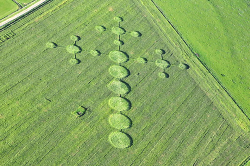
Photo by P hilippe Ullens, Crop Circle Archives (Crop Circle Connector)
Avebury Down, Wiltshire 28 September 2008, wheat, 71 photos
Date 28 September 2008
Place Avebury Down, near Avebury
County or region Wiltshire
Country England
Crop Wheat
GPS 51.43235, -1.83341
Nearest ancient site Avebury Henge, 1.5 km Photos71
Photo by P hilippe Ullens, Crop Circle Archives (Crop Circle Connector)
Photo by P hilippe Ullens, Crop Circle Archives (Crop Circle Connector)
Photo by P hilippe Ullens, Crop Circle Archives (Crop Circle Connector)
Photo by Tammi Paxman, Crop Circle Archives (Crop Circle Connector)
Photo by Tammi Paxman, Crop Circle Archives (Crop Circle Connector)
Photo by Tammi Paxman, Crop Circle Archives (Crop Circle Connector)
Photo by Tammi Paxman, Crop Circle Archives (Crop Circle Connector)
Photo by Tammi Paxman, Crop Circle Archives (Crop Circle Connector)
Photo by Tammi Paxman, Crop Circle Archives (Crop Circle Connector)
Photo by Firefly Reports, Crop Circle Archives (Crop Circle Connector)
Photo by Firefly Reports, Crop Circle Archives (Crop Circle Connector)
Photo by Firefly Reports, Crop Circle Archives (Crop Circle Connector)
Photo by Firefly Reports, Crop Circle Archives (Crop Circle Connector)
Photo by Firefly Reports, Crop Circle Archives (Crop Circle Connector)
Photo by Firefly Reports, Crop Circle Archives (Crop Circle Connector)
Photo by Firefly Reports, Crop Circle Archives (Crop Circle Connector)
Photo by Rob Armstrong, Crop Circle Archives (Crop Circle Connector)
Photo by Rob Armstrong, Crop Circle Archives (Crop Circle Connector)
Photo by Rob Armstrong, Crop Circle Archives (Crop Circle Connector)
Photo by Rob Armstrong, Crop Circle Archives (Crop Circle Connector)
Photo by Rob Armstrong, Crop Circle Archives (Crop Circle Connector)
Photo by Rob Armstrong, Crop Circle Archives (Crop Circle Connector)
Photo by Rob Armstrong, Crop Circle Archives (Crop Circle Connector)
Photo by Rob Armstrong, Crop Circle Archives (Crop Circle Connector)
Photo by Rob Armstrong, Crop Circle Archives (Crop Circle Connector)
Photo by Rob Armstrong, Crop Circle Archives (Crop Circle Connector)
Photo by Rob Armstrong, Crop Circle Archives (Crop Circle Connector)
Photo by Rob Armstrong, Crop Circle Archives (Crop Circle Connector)
Photo by Rob Armstrong, Crop Circle Archives (Crop Circle Connector)
Photo by Rob Armstrong, Crop Circle Archives (Crop Circle Connector)
Photo by Rob Armstrong, Crop Circle Archives (Crop Circle Connector)
Photo by Rob Armstrong, Crop Circle Archives (Crop Circle Connector)
Photo by Rob Armstrong, Crop Circle Archives (Crop Circle Connector)
Photo by Rob Armstrong, Crop Circle Archives (Crop Circle Connector)
Photo by Rob Armstrong, Crop Circle Archives (Crop Circle Connector)
Photo by Rob Armstrong, Crop Circle Archives (Crop Circle Connector)
Photo by Rob Armstrong, Crop Circle Archives (Crop Circle Connector)
Photo by Rob Armstrong, Crop Circle Archives (Crop Circle Connector)
Photo by Rob Armstrong, Crop Circle Archives (Crop Circle Connector)
Photo by Rob Armstrong, Crop Circle Archives (Crop Circle Connector)
Photo by Rob Armstrong, Crop Circle Archives (Crop Circle Connector)
Photo by Rob Armstrong, Crop Circle Archives (Crop Circle Connector)
Photo by Rob Armstrong, Crop Circle Archives (Crop Circle Connector)
Photo by Rob Armstrong, Crop Circle Archives (Crop Circle Connector)
Photo by Rob Armstrong, Crop Circle Archives (Crop Circle Connector)
Photo by Rob Armstrong, Crop Circle Archives (Crop Circle Connector)
Photo by Rob Armstrong, Crop Circle Archives (Crop Circle Connector)
Photo by Julie Obrien, Crop Circle Archives (Crop Circle Connector)
Photo by Julie Obrien, Crop Circle Archives (Crop Circle Connector)
Photo by Julie Obrien, Crop Circle Archives (Crop Circle Connector)
Photo by Julie Obrien, Crop Circle Archives (Crop Circle Connector)
Photo by Julie Obrien, Crop Circle Archives (Crop Circle Connector)
Photo by Julie Obrien, Crop Circle Archives (Crop Circle Connector)
Photo by Julie Obrien, Crop Circle Archives (Crop Circle Connector)
Photo by Julie Obrien, Crop Circle Archives (Crop Circle Connector)
Photo by Julie Obrien, Crop Circle Archives (Crop Circle Connector)
Photo by Julie Obrien, Crop Circle Archives (Crop Circle Connector)
Photo by Julie Obrien, Crop Circle Archives (Crop Circle Connector)
Photo by Julie Obrien, Crop Circle Archives (Crop Circle Connector)
Photo by Julie Obrien, Crop Circle Archives (Crop Circle Connector)
Photo by Julie Obrien, Crop Circle Archives (Crop Circle Connector)
Photo by Julie Obrien, Crop Circle Archives (Crop Circle Connector)
Photo by Julie Obrien, Crop Circle Archives (Crop Circle Connector)
Photo by Julie Obrien, Crop Circle Archives (Crop Circle Connector)
Photo by Julie Obrien, Crop Circle Archives (Crop Circle Connector)
Photo by Julie Obrien, Crop Circle Archives (Crop Circle Connector)
Photo by Tommy Borms, Crop Circle Archives (Crop Circle Connector) , diagram
Photo by Tommy Borms, Crop Circle Archives (Crop Circle Connector)
Photo by Tommy Borms, Crop Circle Archives (Crop Circle Connector)
Photo by Tommy Borms, Crop Circle Archives (Crop Circle Connector)
Temporary Temples Photos load from the archives that published them and remain the copyright of their photographers. Crop circle images and reports courtesy The Crop Circle Connector (cropcircleconnector.com). All sources and credits .
Reports
Crop Circle at 2008. Avebury Down, nr Avebury, Wiltshire. Reported 28th September. Map Ref: Updated Tuesday 14th October 2008 AERIAL SHOTS GROUND SHOTS DIAGRAMS FIELD REPORTS ARTICLES Images P hilippe Ullens Copyright 200 8 THE HENGE SHOP Reconstruction of the 2008 Avebury Down formation By Zef Damen Image Tammi…
Where it was
Open in Google Maps
Same field, other years Avebury Down, Wiltshire 31 July 1997 Avebury Avenue, Wiltshire 13 July 2000 Green Street, Wiltshire 19 July 2000 Avebury Down, Wiltshire 2001 Avebury Stone Avenue, Wiltshire 9 August 2003 Avebury Down, Wiltshire 26 July 2004 Avebury Stone Avenue, Wiltshire 29 July 2005 Overton Down, Wiltshire 18 July 2011 Avebury Stone Circle, Wiltshire 1 August 2012 Green Street, Wiltshire 29 July 2014 Green Street, Wiltshire 19 June 2015 Greenstreet, Wiltshire 16 May 2016 Herepath, Wiltshire 2 July 2021 Falkner's Circle, Wiltshire 8 June 2025 Stone Circle, Wiltshire 14 July 2026