Crop Circle Archives (Crop Circle Connector)
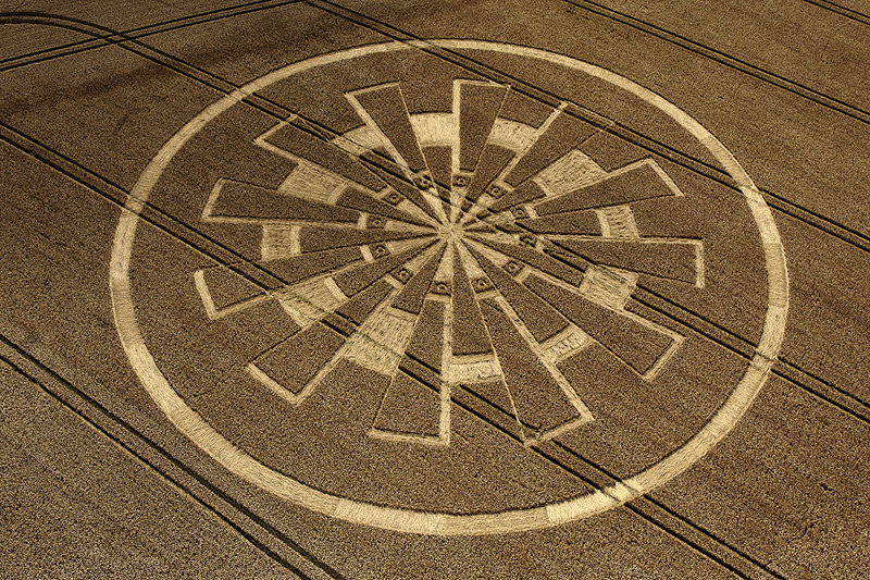
Temple Farm, Wiltshire 7 August 2011, wheat, 42 photos
Date 7 August 2011
Place Temple Farm, near Rockley
County or region Wiltshire
Country England
Crop Wheat
GPS 51.44546, -1.79491
OS grid reference SU 143 718
Nearest ancient site Hackpen White Horse, 3.5 km Photos42
Crop Circle Archives (Crop Circle Connector)
Crop Circle Archives (Crop Circle Connector)
Crop Circle Archives (Crop Circle Connector)
Crop Circle Archives (Crop Circle Connector)
Crop Circle Archives (Crop Circle Connector)
Crop Circle Archives (Crop Circle Connector)
Crop Circle Archives (Crop Circle Connector)
Crop Circle Archives (Crop Circle Connector)
Crop Circle Archives (Crop Circle Connector)
Crop Circle Archives (Crop Circle Connector)
Crop Circle Archives (Crop Circle Connector)
Crop Circle Archives (Crop Circle Connector)
Crop Circle Archives (Crop Circle Connector)
Crop Circle Archives (Crop Circle Connector)
Crop Circle Archives (Crop Circle Connector)
Crop Circle Archives (Crop Circle Connector)
Crop Circle Archives (Crop Circle Connector)
Crop Circle Archives (Crop Circle Connector)
Crop Circle Archives (Crop Circle Connector)
Crop Circle Archives (Crop Circle Connector)
Crop Circle Archives (Crop Circle Connector)
Photo by Bertold Zugelder, Crop Circle Archives (Crop Circle Connector)
Photo by Johan Anderson, Crop Circle Archives (Crop Circle Connector)
Photo by Nyako Nakar, Crop Circle Archives (Crop Circle Connector)
Photo by Nyako Nakar, Crop Circle Archives (Crop Circle Connector)
Photo by AnimalAlien, Crop Circle Archives (Crop Circle Connector)
Photo by Bert Janssen, Crop Circle Archives (Crop Circle Connector)
Photo by Bert Janssen, Crop Circle Archives (Crop Circle Connector)
Photo by Bert Janssen, Crop Circle Archives (Crop Circle Connector)
Photo by Frank Laumen, Crop Circle Archives (Crop Circle Connector)
Photo by Frank Laumen, Crop Circle Archives (Crop Circle Connector)
Photo by Paul Jacobs, Crop Circle Archives (Crop Circle Connector)
Photo by Paul Jacobs, Crop Circle Archives (Crop Circle Connector)
Photo by Paul Jacobs, Crop Circle Archives (Crop Circle Connector)
Photo by Paul Jacobs, Crop Circle Archives (Crop Circle Connector)
Photo by Paul Jacobs, Crop Circle Archives (Crop Circle Connector)
Photo by Paul Jacobs, Crop Circle Archives (Crop Circle Connector)
Photo by Paul Jacobs, Crop Circle Archives (Crop Circle Connector)
Photo by Paul Jacobs, Crop Circle Archives (Crop Circle Connector)
Temporary Temples
Temporary Temples
Temporary Temples Photos load from the archives that published them and remain the copyright of their photographers. Crop circle images and reports courtesy The Crop Circle Connector (cropcircleconnector.com). All sources and credits .
Reports
Crop Circle at Temple Farm, Nr Rockley, Wiltshire. Reported 7th August 2011. Temple Farm, Nr Rockley, Wiltshire. Reported 7th August. Map Ref: SU143718 Updated Wednesday 7th March 2012 AERIAL SHOTS GROUND SHOTS DIAGRAMS FIELD REPORTS COMMENTS ARTICLES 08/08/11 08/08/11 13/09/11 08/08/11 07/03/12 14/08/11 Video by…