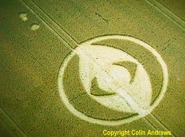
Photo by Colin Andrews, Crop Circle Archives (Crop Circle Connector)
- Date
- 23 July 2000
- Place
- Hodson, near Chiseldon
- County or region
- Wiltshire
- Country
- England
- Crop
- Wheat
- GPS
- 51.51644, -1.74595
- OS grid reference
- SU 1772 7975
- Nearest ancient site
- Barbury Castle, 4.4 km
- Reference codes
- LP-CCDB uk2000cq
Photos21
Photos load from the archives that published them and remain the copyright of their photographers. Crop circle images and reports courtesy The Crop Circle Connector (cropcircleconnector.com). All sources and credits.
Reports
Crop Circle Archives (Crop Circle Connector)
Hodson, nr Chiseldon, Wiltshire. Reported 23rd July. ContentZone Hodson (1), nr Chiseldon, Wiltshire. Reported 23rd July. GPS Reference SU17727975 Updated Wednesday 27th September 2000 Image Colin Andrews Copyright 2000 ( CPRI ) Image Steve Alexander Copyright 2000 Click on the left hand side formation for report…
Photos by Colin Andrews, Steve Alexander, Stuart Dike & M.J.Fussell, Stuart Dike. Read the full report at Crop Circle Archives.
Crop Circle Archives (Crop Circle Connector)
Hodson (2), nr Chiseldon, Wiltshire. Reported 23rd July. ContentZone Hodson (2), nr Chiseldon, Wiltshire. Reported 23rd July. GPS Reference SU17747964 Updated Friday 29th September 2000 Image Colin Andrews Copyright 2000 ( CPRI ) Copyright Colin Andrews www.CropCircleInfo.com Image Steve Alexander Copyright 2000…
Photos by Colin Andrews, Steve Alexander, Stuart Dike. Read the full report at Crop Circle Archives.
Lucy Pringle Crop Circle Photography
An ellipse within a ring, with two crescents within the ellipse, resembling an 'eye'
Photos by Lucy Pringle. Read the full report at Lucy Pringle.