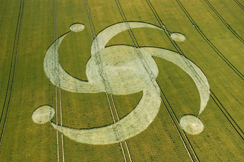
Photo by Steve Alexander, Crop Circle Archives (Crop Circle Connector)
- Date
- 11 July 2004
- Place
- Steep Down, near Sompting, nr
- County or region
- West Sussex
- Country
- England
- Crop
- Wheat
- GPS
- 50.85755, -0.34688
- OS grid reference
- TQ 164 077
- Nearest ancient site
- Cissbury Ring, 2.4 km
- Reference codes
- LP-CCDB uk2004az, CCRA ENSW200401
Photos19
Photos load from the archives that published them and remain the copyright of their photographers. Crop circle images and reports courtesy The Crop Circle Connector (cropcircleconnector.com). All sources and credits.
Reports
Crop Circle Archives (Crop Circle Connector)
Crop Circle at Steep Down, nr Sompting, nr West Sussex. Reported 11th July 2004. Steep Down, nr Sompting, nr West Sussex. Reported 11th July. Map Ref: TQ164077 Updated Thursday 15th July 2004 Discuss this Crop Circle on the Forum Images Steve Alexander Copyright 2004 Code: SUSSEX 2004/06 Location: STEEP DOWN HILL,…
Photos by Steve Alexander. Read the full report at Crop Circle Archives.
Lucy Pringle Crop Circle Photography
Four crescent arms equidistantly arranged around a central circle. Each 'arm' ends touching a smaller grapeshot circle Four crescent arms equidistantly arranged around a central circle. Each 'arm' ends touching a smaller grapeshot circle
Photos by Lucy Pringle. Read the full report at Lucy Pringle.