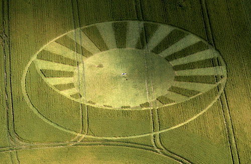
Photo by James Willard-Smith Jnr, Crop Circle Archives (Crop Circle Connector)
- Date
- 13 July 2004
- Place
- West Kennett Longbarrow, near Silbury Hill
- County or region
- Wiltshire
- Country
- England
- Crop
- Wheat
- GPS
- 51.40836, -1.84920
- OS grid reference
- SU 1058 6771
- Nearest ancient site
- West Kennet Long Barrow, 0.1 km
- Reference codes
- LP-CCDB uk2004ba
Photos23
Photos load from the archives that published them and remain the copyright of their photographers. Crop circle images and reports courtesy The Crop Circle Connector (cropcircleconnector.com). All sources and credits.
Reports
Crop Circle Archives (Crop Circle Connector)
Crop Circle at West Kennett Longbarrow, Nr Silbury Hill, Wiltshire. Reported 13th July 2004. West Kennett Longbarrow, Nr Silbury Hill, Wiltshire. Reported 13th July. Map Ref: SU10586771 GPS Updated Tuesday 3rd August 2004 Discuss this Crop Circle on the Forum Click on Thumbnails to enlarge © James Willard-Smith Jnr…
Photos by James Willard-Smith Jnr, Stuart Dike, Eva Brekkestø, Steve Alexander, Verity Bullock. Read the full report at Crop Circle Archives.
Lucy Pringle Crop Circle Photography
An eliptical shape containing a number of 'bars' spanning out at one end. Resembles a kind of 'sun burst' design An eliptical shape containing a number of 'bars' spanning out at one end. Resembles a kind of 'sun burst' design. An eliptical shape containing a number of 'bars' spanning out at one end. Resembles a…
Photos by Lucy Pringle. Read the full report at Lucy Pringle.