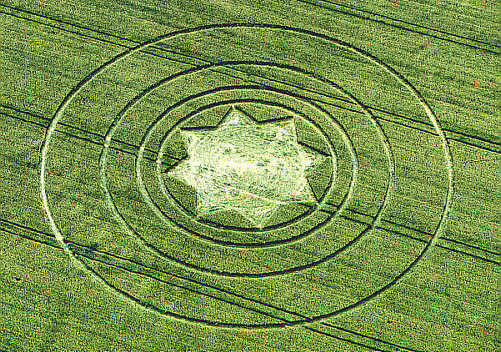
Photo by Steve Alexander, Crop Circle Archives (Crop Circle Connector)
Silbury Hill (2), Wiltshire 11 June 2000, barley, 30 photos
Date 11 June 2000
Place Silbury Hill (2), near Avebury
County or region Wiltshire
Country England
Crop Barley
GPS 51.41926, -1.86729
OS grid reference SU 0932 6892
Nearest ancient site Silbury Hill, 0.8 km
Reference codes LP-CCDB uk2000ap Photos30
Photo by Steve Alexander, Crop Circle Archives (Crop Circle Connector)
Photo by Stuart Dike, Crop Circle Archives (Crop Circle Connector)
Photo by Sørensen, Crop Circle Archives (Crop Circle Connector)
Photo by Stuart Dike, Crop Circle Archives (Crop Circle Connector)
Photo by Stuart Dike, Crop Circle Archives (Crop Circle Connector)
Photo by Stuart Dike, Crop Circle Archives (Crop Circle Connector)
Photo by Stuart Dike, Crop Circle Archives (Crop Circle Connector)
Photo by Stuart Dike, Crop Circle Archives (Crop Circle Connector)
Photo by Stuart Dike, Crop Circle Archives (Crop Circle Connector)
Photo by Steve Alexander, Crop Circle Archives (Crop Circle Connector)
Photo by Steve Alexander, Crop Circle Archives (Crop Circle Connector)
Photo by Steve Alexander, Crop Circle Archives (Crop Circle Connector)
Photo by Stuart Dike, Crop Circle Archives (Crop Circle Connector)
Photo by Stuart Dike, Crop Circle Archives (Crop Circle Connector)
Photo by Stuart Dike, Crop Circle Archives (Crop Circle Connector)
Photo by Stuart Dike, Crop Circle Archives (Crop Circle Connector)
Photo by Stuart Dike, Crop Circle Archives (Crop Circle Connector)
Photo by Stuart Dike, Crop Circle Archives (Crop Circle Connector)
Photo by Stuart Dike, Crop Circle Archives (Crop Circle Connector)
Photo by Sørensen, Crop Circle Archives (Crop Circle Connector)
Photo by Steve Alexander, Crop Circle Archives (Crop Circle Connector)
Photo by Steve Alexander, Crop Circle Archives (Crop Circle Connector)
Photo by Steve Alexander, Crop Circle Archives (Crop Circle Connector)
Temporary Temples
Temporary Temples
Temporary Temples
Temporary Temples
Temporary Temples
Photo by Lucy Pringle, Lucy Pringle Crop Circle Photography
Photo by Lucy Pringle, Lucy Pringle Crop Circle Photography Photos load from the archives that published them and remain the copyright of their photographers. Crop circle images and reports courtesy The Crop Circle Connector (cropcircleconnector.com). All sources and credits .
Reports
Silbury Hill (2), nr Avebury, Wiltshire. Reported 11th June. ContentZone CROP CIRCLES IN 2000 Silbury Hill (2), nr Avebury, Wiltshire. Reported 11th June. GPS Reference SU09326892 Updated Monday 19th June 2000 Images Steve Alexander Copyright 2000 Image Stuart Dike Copyright 2000 EIGHT-FOLD STAR One of two…
An eight pointed star in a circle surrounded by 4 rings An eight pointed star in a circle surrounded by 4 rings