Crop Circle Archives (Crop Circle Connector)
- Date
- 20 June 2005
- Place
- Monkton Down, near Winterbourne Monkton
- County or region
- Wiltshire
- Country
- England
- Crop
- Wheat
- GPS
- 51.44821, -1.82799
- OS grid reference
- SU 120 721
- Nearest ancient site
- Avebury Henge, 2.8 km
- Reference codes
- LP-CCDB uk2005ar
Photos12
Photos load from the archives that published them and remain the copyright of their photographers. Crop circle images and reports courtesy The Crop Circle Connector (cropcircleconnector.com). All sources and credits.
Reports
Crop Circle Archives (Crop Circle Connector)
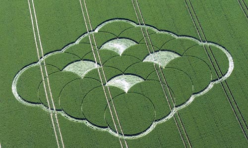
Crop Circle at Monkton Down, nr Winterbourne Monkton, Wiltshire. Reported 20th June 2005 Monkton Down, nr Winterbourne Monkton, Wiltshire. Reported 20th June. Map Ref: (VERY APPROX) SU120721 Updated Monday 27th June 2005 Thank you to Michael Glickman for passing on to the web site news that the farmer has put out a…
Photos by Steve Alexander, Bertold Zugelder, Lucy Pringle, John Dove. Read the full report at Crop Circle Archives (2 pages).
Lucy Pringle Crop Circle Photography
25 overlapping rings forming a 5x5 diamond shape. Four of the inner ones are flattened
Photos by Lucy Pringle. Read the full report at Lucy Pringle.